
Lt30/Lt30A/Lt300/Lt500 Series Handheld Terminal Professional Surveying & Mapping Solution GPS/Gis
- Payment Type:
- T/T, Paypal, Money Gram, Western Union
Your message must be between 20 to 2000 characters
Contact Now| Place of Origin: | China |
|---|---|
| Payment Type: | T/T, Paypal, Money Gram, Western Union |
2014 hot selling China brand LT30/LT30A/LT300/LT500 Real Time And SBAS Diffrential With 1m Accuracy DGPS GIS solutions
Product Introductions
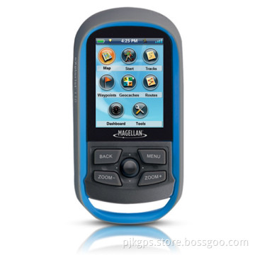
LT30/LT30A/LT300/LT500 is our company's newest instrument since PJK-8. It has introduced a new large- screen, high -capacity , portable GPS, GPS measurement collection , communication , camera in one device , the appearance of the atmosphere , high-definition screen .The special three anti- technology enables it to compete with everything in the wild . Along with the top IP68 protection, can completely prevent water and dust from entering inside the body , the whole body with a non-slip rubber material , can be well protected from being damaged when the body was harsh environments.

Product Features
GPS
GPS Navigation : Built-in GPS, support A-GPS
Single precision :3- 5 m , 1-3 m difference
Sensor Type : Support gravity , light , proximity sensor ,
Electronic compass: In case no GPS satellite signals can indicate the direction
Protection class : IP68 waterproof , 1.5 meters deep in the water can soak for 30 minutes still work , anti 1 meter free-fall down
Basic characteristics
Operating system : Android 4.0
Screen: 4 inch capacitive screen, multi-touch
Resolution : 800x480 pixels
Network mode : GSM, WCDMA
Network type: dual card dual-mode
CPU Model: Qualcomm Snapdragon MSM8225 Xiaolong
CPU Frequency : 1024MHz dual-core
Battery capacity : 3200mAh removable battery
RAM capacity : 768MB
ROM Capacity : 4GB
Memory card : MicroSD card Extended Capacity : 32GB
Standby time : 200 hours
Dimensions : 139x74x18.5mm
More Applications
WLAN features: WIFI
Browser: WAP 2.0 support
Data interface : Micro USB
Headphone jack : 3.5mm
Bluetooth : 2.1 + EDR + A2DP
Video Player : Support 3GP/MP4, AVI, RMVB format and other formats , radio , e-book
Camera
Rear camera pixels: 8,000,000 pixels
Front camera pixels: 300,000 pixels
Sensor Type : CMOS
Flash : LED lights
Image size: maximum support 3264 × 2448 pixel photo shoot
Other features: camera features to optimize image stabilization
Professional data acquisition system :
Load mobile GIS data collection systems , easily RBI , measuring area , navigation and other field
measurements
Navigation :
Covers a number of cities across the country navigation and details , along with intelligent navigation
functions. Real-time navigation information : real-time display speed, altitude , heading, distance, time, date and other information. Record Information : store
waypoints (including plane coordinates , altitude, time , name, description and type ) , and supports route
method and measured track area .
Information stored indicator :
Waypoint countless , countless tracks , a track record eight hours of continuous ; route countless , each up to 1000 waypoints . Area Calculation : area measurement functions with intuitive tracks and routes can use to calculate the area , area measurement record keeping ; area measurement results with "square ", " mu ",
" ha " and many other units.
Coordinate transformation :
Can set user-defined coordinate system support CGCS2000 coordinates, and can be viewed
simultaneously WGS84, Beijing 54 and Xi'an 80 coordinate a variety of custom coordinate systems .
The processed data :
The supporting industry data processing software , supports a variety of import and export data formats
(EXCEL, KML, TRL, MIF, DXF, SHP, TXT and other formats ) , while supporting the import Jia Ming , Magellan , ZYSTAR other brands of GPS data and export , with field mapping and printing capabilities.

Related Keywords