
Ashtech Gis Mm100 Mm120 Handheld GPS
- Payment Type:
- T/T, Western Union, Paypal, Money Gram
Your message must be between 20 to 2000 characters
Contact Now| Place of Origin: | USA |
|---|---|
| Payment Type: | T/T, Western Union, Paypal, Money Gram |
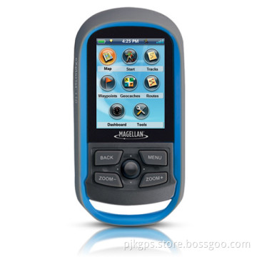
Ashtech GIS MM100 MM120 handheld GPS
 MobileMapper 100 is the newest generation of GNSS handheld mapping devices introduced by Ashtech.
Designed for GIS data collection and mapping, the MobileMapper 100 integrates an open operating system, built in communications and the Ashtech's powerful BLADE technology.
BLADE allows the MobileMapper100 to operate in extreme GNSS environments while maintaining the high accuracies desired by GIS professionals.
Ashtech MobileMapper 100 delivers state-of the art features in a smart, compact,
and lightweight handheld concept that gives users the ultimate field experience.
Combined with MobileMapper Field proprietary software or Ashtech Business partners'
offerings, MobileMapper 100 brings the openness, flexibility and scalability needed to
answer any mobile GIS requirements.


High-Accuracy Handheld
True handheld operations
Powerful BLADE processing technology
Sub-meter, decimeter or centimeter real-time accuracy modes
Extended position availability in urban canyons and under canopy
Designed For The Field
Compact & lightweight design for optimal mobility, use and comfort
Integrated communications for easy data transfer and GNSS differential
Powerful electronics for fast data collection and seamless processing
Ruggedized for outdoor use in extreme conditions
Flexible
Extended Connectivity and multimedia features
Windows Mobile standards for full 3rd party software compatibility
Ancillary sensors interfacing
GNSS scalability: GPS or GPS/Glonass configurations
Compatible with 3rd party networks (VRS, FKP, MAC)
MobileMapper Field and Office Software
Complete solution:
The Ashtech MobileMapper software suite includes all GIS features that professionals really need without the burden of complicated and rarely used functions. It also provides a direct interface to external sensors such as range laser finders.
Windows Mobile Openness:
With Windows Mobile 6.5 you may upload any necessary utility or software on your MobileMapper 100, whatever suits your next job. You can collect GIS/GPS points and maps via the GIS application of your choice, either a third party software such as ESRI® ArcPad® or the proprietary Ashtech application.
Software Choice:
Take advantage of the solutions that Ashtech Business Partners are offering. Either in Forestry, Agriculture, Utility asset management, Underground cable location, etc the application choice is large. Specific GIS software or hardware solution combined with your
MobileMapper 100 form an accurate all-in-one mobile GIS solution,
100% matching your professional needs
Product specifications
· Constellation : GPS, GLONASS, SBAS
· Channels : 45
· Frequency : L1,L2
· Update Rate : 0.05 sec
· Data format : RTCM 3.1, ATOM, CMR(+), NMEA
· Raw data output : Yes
· Real-time Accuracy - RTK mode (HRMS) : 1 cm
· Real-time Accuracy - DGPS mode (HRMS) : < 30 cm
· Real-time Accuracy - SBAS mode (HRMS) : < 50 cm
· Post-Processed Accuracy (HRMS) : < 30 cm down to 1 cm
· Time to first fix : 15 sec
· Initialization range : Below 10 kms in L1
· Processor : 806 MHz
· Operating system : Windows Mobile 6.5
· Communications : GSM/GPRS, BT, WLAN
· Unit size (mm / inches) : 190x90x43mm / 7.5x3.5x1.7in
· Weight : 0.62 kg / 1.43 lb
· Display : 3.5
· Memory : 256 MB SDRAM / 2 GB NAND / SDHC
· Temp Min (°C) : -20°C / -4°F
· Temp Max (°C) : 60°C / 140°F
· Waterproof : IP 65
· Shock & vibration : ETS300 019 & MIL-STD-810
· Power (type - lifetime) : 6600 mAh Li-Ion / > 8 hrs
· Antenna Type : Internal / External
· Firmware options : Yes
· Software options : Yes

Related Keywords